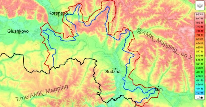
The current situation in Kursk Oblast, a region in Russia located near the border with Ukraine, is a matter of concern and interest for many. To better understand the dynamics at play in this area, a topographic map has been created based on geolocations and reliable reports.
The map uses different colors to represent various aspects of the situation. Black indicates the international border between Russia and Ukraine, while red marks the estimated Russian line of control and blue shows the estimated Ukrainian line of control. The area between the red and blue lines is considered contested, with neither side currently holding positions there.
It is important to note that the information used to create this map is limited, and some areas are based on footage and reports that may not be entirely accurate. As such, this map should be seen as an approximation rather than a definitive representation of the ground situation.
One key takeaway from this map is the significance of high ground in military operations. Both Ukraine and Russia are strategically positioning themselves on elevated terrain, recognizing the tactical advantage it provides. This explains the fierce competition and localized breakthroughs that have been observed in the Pokrovsk direction.
Overall, this map serves as a visual aid to help observers gain a better understanding of the current situation in Kursk Oblast. By highlighting the contested areas and emphasizing the importance of high ground, it sheds light on the strategic considerations at play in this region.

